Back Atol Saint-Joseph Catalan Saint-Joseph-Atoll German Atoll Saint-Joseph French St. Joseph NB Saint-Joseph (atol) Polish
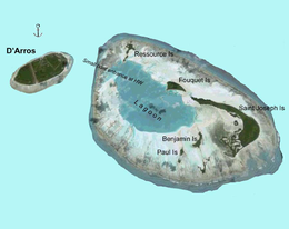
 Map of D'Arros Island and neighboring St. Joseph Atoll, part of the Amirante Islands group | |
| Geography | |
|---|---|
| Location | Indian Ocean |
| Coordinates | 05°24′S 53°18′E / 5.400°S 53.300°E |
| Type | Atoll |
| Archipelago | Seychelles |
| Adjacent to | Indian Ocean |
| Total islands | 13 |
| Major islands |
|
| Area | 1.632 km2 (0.630 sq mi) |
| Highest elevation | 3 m (10 ft) |
| Administration | |
| Group | Outer Islands |
| Sub-Group | Amirante Islands |
| Sub-Group | D'Arros and St. Joseph Atoll Special Reserve[1] |
| Districts | Outer Islands District |
| Largest settlement | St. Joseph (pop. 0) |
| Demographics | |
| Population | 0 (2014) |
| Pop. density | 0/km2 (0/sq mi) |
| Ethnic groups | Creole, French, East Africans, Indians. |
| Additional information | |
| Time zone | |
| ISO code | SC-26 |
| Official website | www |
Saint Joseph Atoll is part of the Amirante Islands group, which are in the Outer Islands (Coralline Seychelles) coral archipelago of the Seychelles islands and nation. The atoll is located southwest of the granitic Inner Seychelles archipelago, with a distance of 248 km south of Victoria, Seychelles.
